
June 5, 2022
Brandy has been very ambitious with wanting to get out and hike these last few weeks. She asked me to find a trail for us for this weekend and when I asked how far she was willing to drive, she asked, “Why, where do you want to go?”
I suggested Backbone State Park, about an hour and a half drive from home. She was willing, so we made that trip last Saturday.
Prep and Departure
I packed us up a few things for lunch and snacks as we knew we’d be gone for the better part of the day. We filled our water bottles, Brandy made a cup of iced coffee and we packed Ash up in the car before heading out at about 9:15. I was wearing my hiking boots for the first time in a while so I took a pair of my Vans to change into afterwards.
After exiting the 380 just north of Cedar Rapids, we began winding our way through rural back roads, making our way through the vast expanses of Iowa farmland. I called to attention how different this environment is for me. I’ve lived in a lot of different types of areas in the US: the hustle and bustle of LA and Las Vegas, the beachy vibes of Florida, the relaxed atmosphere of Albuquerque, but living in the farmlands of the US is a whole new world for me.
Arrival
We pulled into the south gate of Backbone State Park with no signal on our phones. I did not plug the trailhead into the GPS, just the park. We entered the park and went to try to find an information booth where we could find out how to get to the Backbone Trail. We managed to find our way without that information, re-exiting the park through the south gate and continuing north on 140th Ave. After a left on 120th St, we found ourselves entering the east gate of the park. We passed the trailhead in search of toilets and hit a series of switchbacks through the lush, green woods.
We found the toilets, did what we needed to do then headed back to the trailhead.
Backbone State Park Trail Loop
AllTrails lists this trail as an easy 1 mile loop trail with a 118 foot elevation gain. As Brandy was getting out of the car, I noticed she had something in her hair. I picked it out and realized it was a small inchworm. Thinking nothing of it, I flicked it off of my fingers and we headed to the trailhead.
The first part of the trail is a fairly narrow trail with steep drop-offs on either side of the trail. It wasn’t quite narrow enough to trigger the anxiety I felt on the La Luz trail last August, but it was notable.
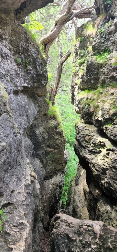
We eventually came to a short, narrow slot between two rock formations. The trail headed to the left of that, but I insisted on going down the slot to see what it was like.
Spoiler alert: It was amazing!
Before I entered the slot, it looked like it was going to be a tight fit, but as I got in there, it opened up and I walked in with relative ease. I went back as far as I could before coming to a pile of rocks at the end. I could have climbed over but I didn’t know what was on the other side, if it was a straight drop-off or what, and I had Ash with me, so I snapped a couple pictures and turned back to the mouth of the gouge where Brandy waited for me.
We continued on for less than a quarter of a mile when we hit the fork in the road. We gauged our options: head left to go up or go right to stay level. We’d eventually have to go up to get to the top of where going left would have taken us, but that’s the option we elected.
The trail suddenly became much less rocky and we were once again in the vibrant green of the Iowa forests. It was much more quiet than we were expecting it to be on such a nice day on such a beautiful trail in such a beautiful state park. We only encountered a small handful of people on the short hike. What did encounter in spades though was more inchworms. As we walked, we constantly ran into them dangling on threads from the canopy.
As the trail hooks back around to start heading back to the fork, the trail again finds itself perched on the edge of a sharp drop-off, this time on our right. At the bottom of that drop runs the Maquoketa River, which led me to the understanding that we were not far from Maquoketa Caves State Park (which is on my to-do list.)
After a short, shallow incline, we found ourselves at the top of the incline where we’d decided to go right instead of left. We headed back down to the fork in the road and continued on, passing the scenery we had just passed maybe 15 minutes earlier.
Less than an hour after we embarked on the hike, we were back at the car. We picked off the last of the inchworms lingering in our hair, on our clothes and shoes, and even on Ash.
Overall, it was a magnificent hike. The scenery is wonderful and varied, the trail is easy, yet challenging as it was not well defined at times, but we made it through without incident.
The Cave
One of the other features of the park I wanted to check out is The Cave. I didn’t know where it was from where we were so we headed back up to the south gate where I had seen signs for an information booth the first time we entered there. We wound our way about trying to find it but for the life of me, I did not spot it. We eventually turned around and headed back toward the gate when I spotted it off to the side, tucked behind a stand of trees. I pulled up and saw that it was a small office building with a map for me to take a picture of. I did and looked, seeing that the cave was most easily accessed through the east gate.
So, we headed back up to the east gate and followed the road around until we came to a sign announcing, The Cave:
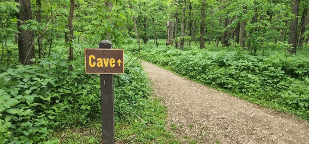
We made the quick walk up to the base of the set of steps leading up to the small cave. We headed up a path that was off to the right instead. It was short but pretty steep but we managed.
The cave is small, maybe 5 feet tall, and only about 30 feet deep. I couldn’t get into it without stooping way down. We checked it out a little bit, took some pictures and found a path leading away from the cave at the base of the hill the cave was in. We walked up the path a bit before it became washed out and dangerous to try. We turned back to the top of the staircase and made our way down, nearly slipping off of the wet stones of the stairs.
The Return
After departing the Cave, we decided to drive through the rest of the park just to see the beautiful scenery. It was a magnificent day, topping out in the mid-70s, sunny, not too hot, not humid. We passed by a marvelous stone wall behind which was a decrepit old building that looked like a falling garage. (We later found out that it used to be a trout hatchery that closed in 1987.)
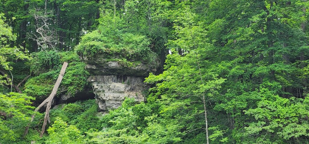
We also passed a sign announcing Balanced Rock which was perched high above the Maquoketa River just off the trail we had hiked upon our arrival.
After a quick stop to munch our lunches, we headed back out the east gate and headed back to the south gate where Brandy had noticed a sign mentioning a beach area. We followed the signs to the shore of the Backbone Lake where indeed there were several people enjoying the beachy atmosphere in the pleasant late spring day.
We continued up the road a bit to find some cabins available for rent. We pledged to look those up in more detail when we got home.
On the way back out, we passed by a small store on the beach. I parked and left Brandy and Ash in the running car and went in to see what would be for sale.
It was effectively a concession stand, offering quick meals like burgers and hot dogs and the like, with a cooler full of sodas and waters and such. One thing they also offered was hand-scooped ice cream. I decided to end the perfect day with a couple cones for chocolate peanut butter ice cream for Brandy and myself.
We left Backbone State Park and made the hour and a half drive back home.
Conclusion
Our trip to Backbone State Park was an absolute dream. The weather was perfect, the hike was a perfect combination of easy and challenging, the scenery was otherworldly beautiful, and we ended the trip with ice cream?! I mean, c’mon, it really doesn’t get any better than that, does it?
We suspect that Backbone State Park will be a regular stop for us, especially during the tolerable weather (spoiler alert: that changed in a hurry! See my next post for more!)
I’ve posted all of the pictures from this trip over on my Photo Diary, make sure you head over there to check ’em out.
I’m going to make a quick post about our outing this past weekend. It’s going to be a short post because it was a short, miserable trip that I don’t even really want to post about, but hey, gotta take the bad with the good, right?
As always, I appreciate every one of you (the one of you) that stops by to read about our adventures.
Until next time!
-Phil
Pingback: Palisades-Kepler State Park, Mount Vernon – The Trip That Wasn’t – Wandering New Mexican
Pingback: Maquoketa Caves State Park – Wandering New Mexican